
 Sign in
The 2026 geographical model making competition focused on students getting involved and exploring their creativity and geographical knowledge by creating a 3D model on the theme of fragile environments.
The goal was for students to design and make a geographical theme 3D model of a key feature of their local area using reused or waste cardboard as the main material supported with other recycled materials.
There were three categories.
Two categories for Individual entries:
- KS2 (Years 3, 4, 5, 6)
- KS3 (Years 7, 8, 9)
One category for a group entry (any sized group from 2 students or more):
- KS2 (Years 3, 4, 5, 6)
The judges looked at the geographical relevance of the place represented by the model, the detailed and geographically written explanation, the originality and creativity of the model and the quality and design of the model build.
We received many brilliant entries from students from a range of age groups, schools and countries. We would like to thank everyone involved and for all the entries.
Key Stage 2 category
1st place: Isabelle Naylor, Hinchley Wood Primary School
Description:
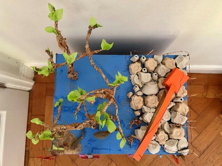
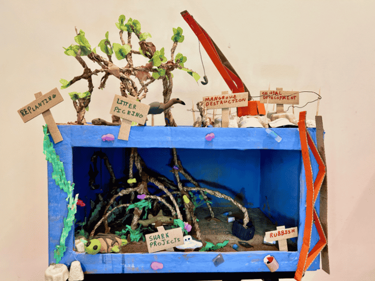
My model represents the mangroves in Bimini (Bahamas), including the wildlife you would find in the Mangroves (baby lemon shark hiding in the roots, green turtle snacking on seaweed, a ray, a bimini boa and a reddish egret).
My model is made out of a recycled cardboard box and other recycled materials, such as egg boxes for rocks, and paper packaging that I twisted to make trunks and roots, and tore up and painted to make seaweed. For the litter, I used recycled carrier bags to make smaller carrier bags, glue sticks to make water bottles, and pringles packaging to make tin cans. I made the wildlife out of left over clay.
People are chopping down the mangroves to build hotels for tourists. This is a problem because the mangroves protect the island from extreme weather and act as a nursery for baby lemon sharks and other sea creatures. This is particularly bad because Bimini is a shark sanctuary with many different types of sharks, and without the nursery, baby sharks are more vulnerable and sharks might become extinct.
In my model on one side you can see the threats to the mangroves including a crane for building, stumps where mangroves have been chopped down and rubbish in the sea. On the other side you can see a healthy mangrove, baby mangroves being planted, thriving wildlife (being protected by shark awareness and conservation projects) and no litter (due to local litter picking projects).
These projects are vital because they will help sharks grow in number, protect local wildlife from rubbish and pollution, and by protecting the mangroves protect the island of Bimini from hurricanes.
Judges comments:
‘This was a fantastic model that made particularly effective use of the space both above and below the surface to show the mangrove roots. The creative design made the geographical features very clear and helped bring the model to life. They also showed a clear understanding of how mangrove environments can be protected via projects. The pupil also named relevant species and used a wide range of materials effectively to create a detailed and engaging model.’
2nd place: Alice Tattersall, Beeston Hall School
Description:
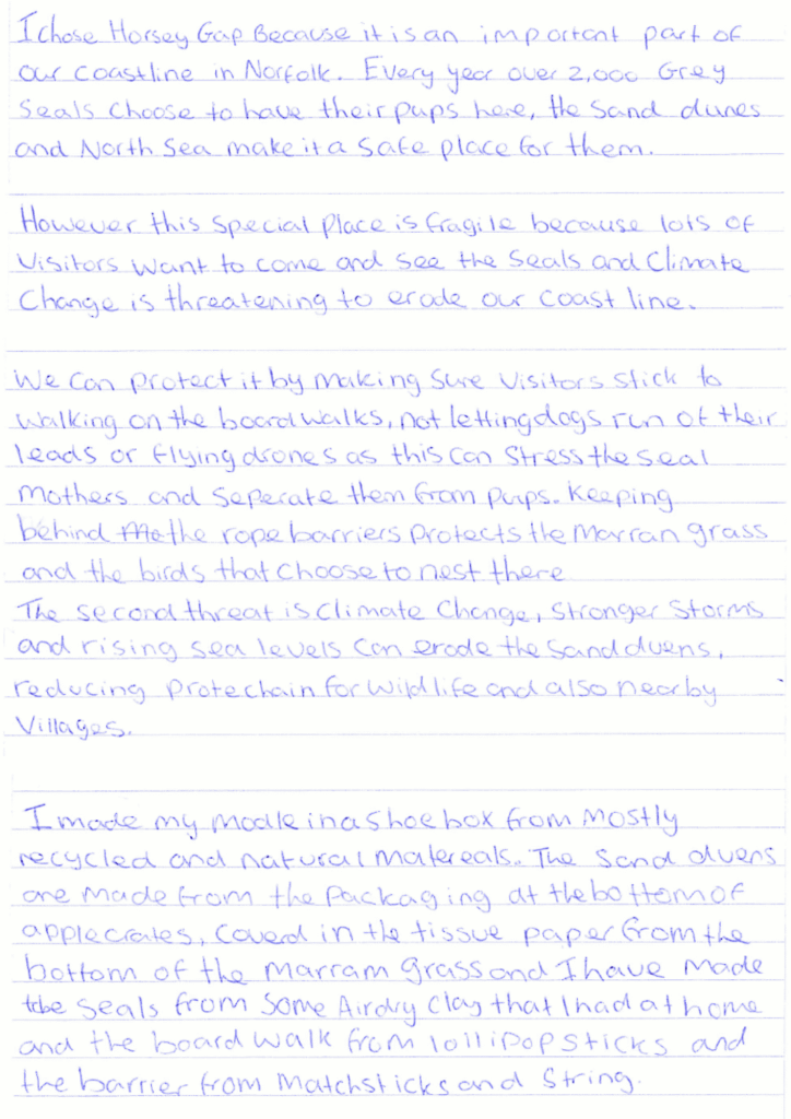
Judging comments:
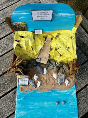
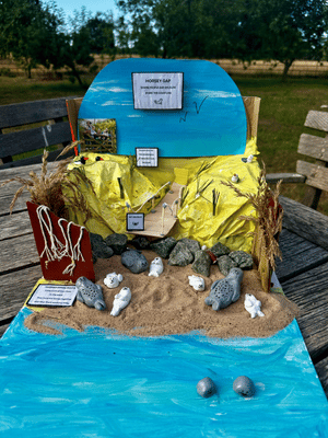
‘This was a lovely 3D model that created a strong sense of the geographical feature being represented. The three-dimensional construction was effective and showed considerable care and attention to detail.
The use of clear and informative labels also helped to communicate the key features of Horsey Gap and made the model easy to understand and in the written explanation they clearly explained the role of the conservation measures. The pupil used a wide range of materials to make their model.’
3rd place: Alex Vaughan, Hinchley Wood Primary School
Description:
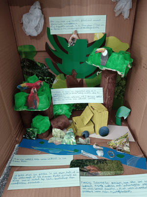
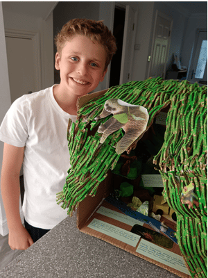
My model is of a rainforest, one of the most fragile environments on the planet. I created it using recycled cardboard, tissue paper and old magazine photos.
The model shows the diversity of the plants and animals and a river flowing through them. However, it also has a bulldozer to represent deforestation and plastic/rubbish pollution floating in the water.
My model shows both the positive and negative sides of the rainforest, with the labels highlighting interesting facts about the rainforest – did you know that more than half of the world’s plants and animals live in rainforest ecosystems?
It also shows the damage that deforestation and plastic pollution are having on this special place, for example the fact that up to 10% of the plastic found in the ocean ends up in the Amazon. Luckily there are also some ways that people are trying to save the rainforests. For example, forest loss in Brazil, Colombia and Indonesia fell last year by 36%, showing that we can make a difference if we focus our efforts.
Rainforests are very important because we need the trees to help with climate change and to make sure we have clean air to breathe. The rivers in rainforests are connected to the ocean and all of the plastic that ends up in the water hurts animals and is not very nice for the people who live nearby.
I visited a tropical rainforest in Costa Rica last year and it was amazing to see all the animals, including a baby sloth! There was a colossal amount of vegetation there and the animals weren’t scared of people so we saw loads of them. We need to protect these fragile environments for future generations to also enjoy them, just like Costa Rica are doing.
Judging comments:
‘This was a creative and engaging rainforest model that made particularly good use of the height available within the box. The use of data in the explanation was very helpful as it supported the geographical ideas being presented. The annotations within the model were also effective in helping to explain the different features shown.’
Key Stage 3 category
1st place: Zinnia Mallarachi, Northwood College for Girls
Description:
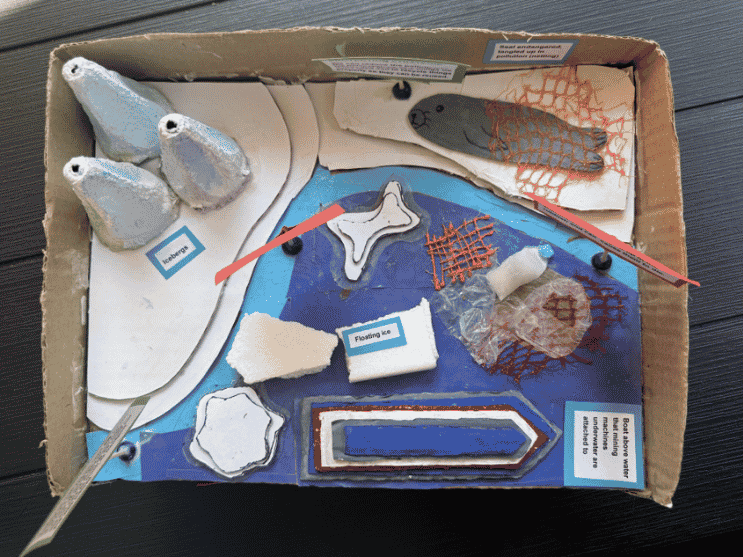
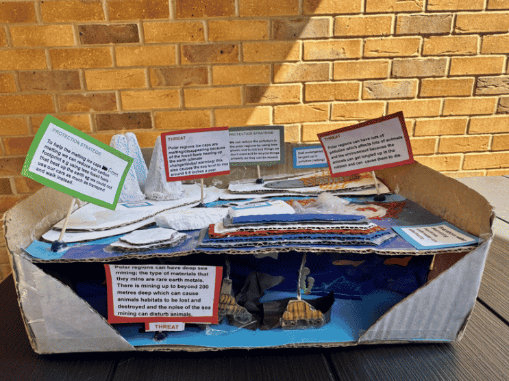
My model is showing the struggles and threats in the polar regions due to climate change and environmental pollution. It represents ways we can prevent those threats from happening.
I made my project using recycled scraps of cardboard, polystyrene, bubble wrap, packaging, plastic and tissue paper.
My geographical idea is to encourage people to use less plastic e.g instead of going to shops to buy a plastic water bottle that you can’t really reuse properly, buy a metal water bottle that can be reused or another type of bottle that can be reused.
Another way is to inform people to not buy things they don’t need so there will be less waste and to help people remember to recycle things properly so they can be reused. This is to help reduce the threat of pollution in the polar regions.
Another idea to help the threats in the polar regions is to inspire people to decrease their carbon footprint. For example, to use less carbon dioxide, greenhouse gases and fossil fuels that heat up the Earth, a way to do that is to promote people to use more sustainable transport such as walking, biking or scooting. And if they can’t walk the whole way they could drive half the way and then park in a car park somewhere then they could walk the rest of the way.
Or to minimise how many people are driving to places, people could sometimes do a car share which means catch a ride in someone else’s car, for example a friend’s car, this is to prevent as many ice caps on the water from melting.
In my local area, rubbish collections are happening every week to make sure people are recycling and disposing of rubbish properly and the council provide the right bin bags for people to buy, they make it that the bin bags are different colors, for example one is black and one is clear, to guarantee the waste, rubbish is clearly separated from things to be recycled the recycling. So it is easy for everyone.
Judging comments:
‘This was an excellent model with a clear geographical focus. The colour coding was particularly effective in showing the different issues and strategies, making the information easy to understand. The use of layers within the model was also a major strength, as it successfully showed both what happens above the water and what lies beneath it. This added depth to the model and demonstrated strong geographical understanding.’
2nd place: Callum McDermott, The Gilberd School
Title: Costal erosion and habitat loss
Description:
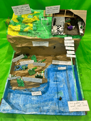
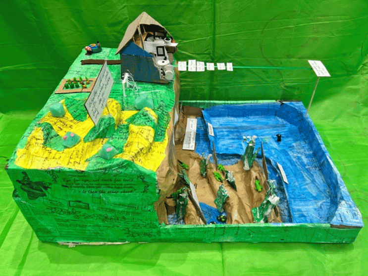
Hemsby is a village, known for the extreme coastal erosion that is making people lose their homes as they fall into the sea, 30 have been destroyed since 2013.
My model shows how erosion has destroyed 300m of the coastline since 1970. My model has two sides, healthy sand dunes that protect the cliffs, or narrow beaches with no cliff protection.
Everything has been built from recycled material, except the modelling clay.
The Norfolk coastline is known for its extremely unique geology. The Hemsby cliffs are made of stacked layers of soft sand, gravel silt and glacial till, left behind by ancient melting ice sheets. Sedimentary layers preserved fossils and environmental history for the last two million years. It is this geology that make the cliffs very fragile to hydraulic action.
Global warming is melting glaciers, causing rising sea levels and extreme weather.
It is not only human habitat that is being lost. Sand dunes used to protect the soft cliffs, are disappearing, taking away the habitats of rare plants and animals that don’t live anywhere else. Natterjack toads are critically endangered and only live in warm water pools in dunes. Sand lizards are also endangered in the UK.
Sand dunes are a natural defence. Healthy dunes move and absorb the power of the waves. Human activity has been the main cause of dune loss, walking, running and driving damages the fragile grasses and without the grass roots the sand is easily washed away.
We should be protecting dunes, replacing grasses, dig up invasive plants that choke the grasses and stop the dune moving, wooden paths for people to walk on and not harm the grasses.
If we want to stop losing our coastline we must look after our sand dunes.
Judging comments:
‘This was a detailed and well-constructed 3D model that effectively represented the coastal environment. The explanation demonstrated a strong understanding of the topic through the use of detailed and appropriate geographical vocabulary. The clear labels on the model also helped to identify and explain the different features, making the geographical ideas easy to follow.’
3rd place: Aliana Storey, The Maynard School
Description:
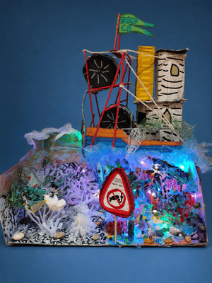
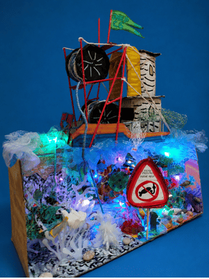
My model is showing a bottom trawling fishing boat floating on the open sea above an expanse of coral reef. The coral reef has been split into two halves: the left half is a lifeless and dead area of coral reef that shows how parts of our seas have been destroyed by bottom trawling.
The right half shows a vibrant, bustling and thriving area of coral reef that is a Highly Marine Protected area which means that bottom trawling is completely illegal in this area and it is an absolute no take zone for complete ecosystem recovery. The contrast between the two sides highlights how we need to look after our seas and protect our marine ecosystems through minimising and even banning bottom trawling due to its severe consequences for our oceans.
Firstly, the base and walls of the model are made out of recycled cardboard on which I drew various coral structures with acrylic paint markers. I used bleaker, blander colours and tones for the dead coral reef side and brighter, vibrant colours for the Highly Marine Protected Area (HMPA) of coral reef to emphasise the contrast between them.
The corals in my model are made out of glue gun and I painted the ones in the Highly Marine Protected Area in bright colours using paint markers whilst I left the ones in the unprotected area plain to represent coral bleaching.The Highly Protected Marine Area corals have colourful beads stuck on with glue gun on them to create sea annomenies and add a bit of sparkle and life.
In addition, the Highly Protected Marine Area coral area has many painted cardboard sea creatures and also some fish cut out from shiny card as well. Furthermore, the coral Highly Protected Marine Area contains corals that are made out of bits of toothbrush heads and pasta that I painted to add different textures and patterns to my model.
The left side of my model contains bits of cut up plastic and kitchen paper to show the pollution in our seas. Water pollution is also shown through the grey walls of the left hand reef. I used rocks from my garden in both the reefs to make them look more authentic.
The bottom trawling boat is made out of recycled cardboard and has been painted with markers. Furthermore, the net reelers on the boat are made out of ropes wrapped around mini glass jars and secured with glue. I used painted cocktail sticks in a variety of ways in my model: to hold up the bottom trawling boat, for the railings of the boat and for the structure of the net reelers.
Finally, the waves below my boat are made out of torn up plastic bags to create the dynamics of the waves moving in the sea. The polluted waters on the left of my model are made out of torn up bin bags and the net below the boat is made out of a mesh pouch from a pack of lemons that has been coloured accordingly.
The geographical idea that my model displays is the destruction of the seabed due to bottom trawling. This is a commercial fishing method where boats drag heavy, weighted nets along the ocean floor to catch bottom-dwelling marine species like cod and shrimp.
I have chosen bottom trawling because it’s an extremely destructive, damaging fishing method that has many negative environmental impacts. Bottom trawling is the most wasteful fishing method. Studies show that nearly half (46%) of annual global fishery discards are caused by bottom trawling. This horrible statistic shows why this fishing method should be banned.
Judging comments:
‘This model communicated a very clear geographical message through the contrasting left and right sides. The difference between the two sides made the impact being demonstrated particularly easy to understand. The explanation clearly described how the model had been created to represent different features of the environment, with a strong focus on the effects of trawling. This gave the model a clear purpose and demonstrated good understanding of a specific geographical issue.’
Group
1st place: Esme Danner and Olivia Molyneux, The School at Galaxy House
Description:
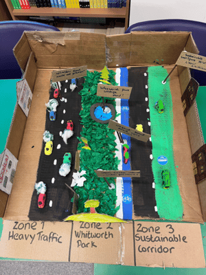
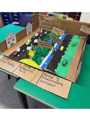
Our 3D model shows Whitworth Park in Manchester, an ‘urban green island’ trapped between two completely different transport zones: the sustainable bus/bike corridor of Oxford Road and the heavy traffic filled Wilmslow Road.
We built our model using mostly waste cardboard boxes for the park base, roads, and buildings. We used tissue paper and cotton wool to create the wildlife habitats. We used air-dry clay to represent the park’s pathways, ponds and surrounding traffic.
Our 3D model shows Whitworth Park in Manchester. It is a special green space for nature, but it is squeezed between two busy roads: the eco-friendly Oxford Road (which is for buses and bikes) and Wilmslow Road (which is packed with cars and traffic).
Our main geographical idea is fragile urban environments. This means green spaces in cities that can be easily hurt by humans. Whitworth Park faces a daily tug-of-war! The heavy traffic on Wilmslow Road causes air pollution that can harm the plants. Also, because thousands of people walk through the park every day, the grass gets trampled and the soil gets squashed. When soil is squashed, tree roots can’t breathe.
We think urban parks are just as fragile as rainforests because the animals living here have nowhere else to go. We believe we must look after them. Our model shows how we could protect the park by using fences to stop people stepping on tree roots, and by leaving wild zones for bees and how the bus and bike lane zone is better.
Small parks are the ‘lungs’ of our city, and we need to protect them so humans and wildlife can share the city safely!
Judging comments:
‘This was a very effective group model with clear zones that made the different areas of the park easy to identify. The use of useful labels helped to explain the features of the model, while the suggestions for managing the small park demonstrated good geographical thinking. The model successfully combined physical representation with ideas about how the space could be used and managed.’
2nd place: Max Evans and Stanley O’Grady, St Brides Major Primary School
Description:
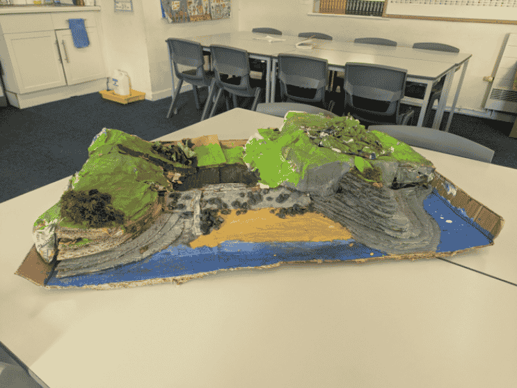
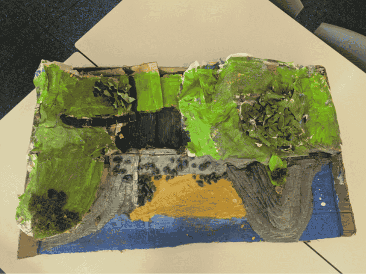
Dunraven bay is made of limestone that got formed millions of years ago to the build up of skeletal fragments of skeletal fragments, crushed up shell and coral. Compressed hard and cements from other materials. Forming the cliffs and bay.
We decided to do the Dunraven estate because it is such a biodiverse environment with rockpools, rabbit warrens, a small deciduous forest, cliffs, caves, a river sprawling with frogs and the castle.
There are a lot of species of wild life like crabs, honeycomb worms living on the beach, birds of prey living on the cliffs, frogs, rabbits, squirrels, foxes, woodland birds, dog fish, bass, mackerel, scad, crabs, molluscs, butterflies and seabirds.
We go to this area a lot to enjoy the beach and make massive sand castles, stand on top of them and see how long they last. I often walk on the cliffs and around the forest. It is fragile because of the ecosystem being under the threat of raw sewage being pumped into the stream which runs to the ocean.
There is also the tourism which causes the problem of litter and air pollution because of the exhaust fumes and the fires lit on the beach. The cliffs face erosion due to the extreme weather caused by climate change.
We believe that if it was a wildlife preserve there will be a lot more awareness and more bins will prevent the littering. If the carpark was on top of the cliffs then it will free up a lot of space due to the carpark at the bottom. Stricter rules about no fires and no overnight stays will help to prevent air pollution.
Judges comments:
‘This was a detailed and engaging group model that showed a good range of wildlife found in the area. It also successfully explored the impact of tourism, demonstrating an understanding that human activity can affect coastal environments. The geology was clearly visible within the model, which added another layer of geographical detail and helped to make the representation more realistic.’
3rd place: Alys Sibieta and Ffion Holland, St Brides Major Primary School
Description:
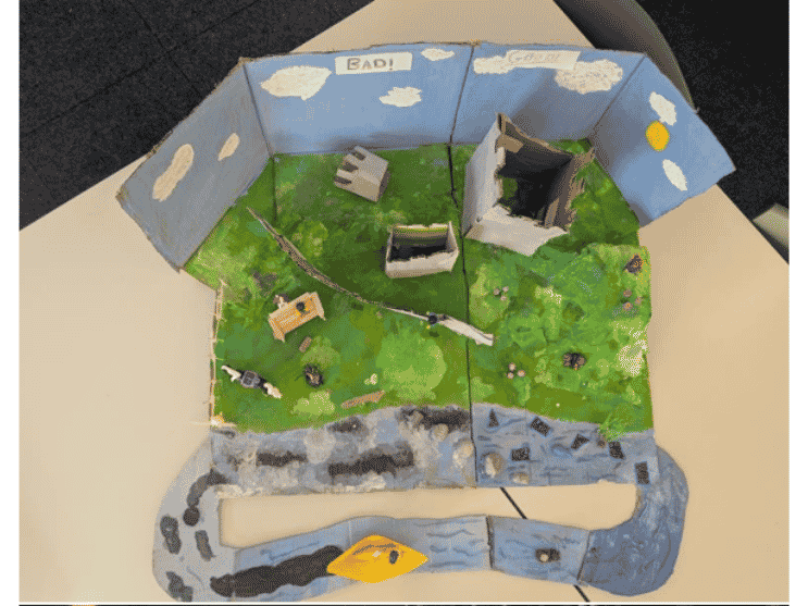
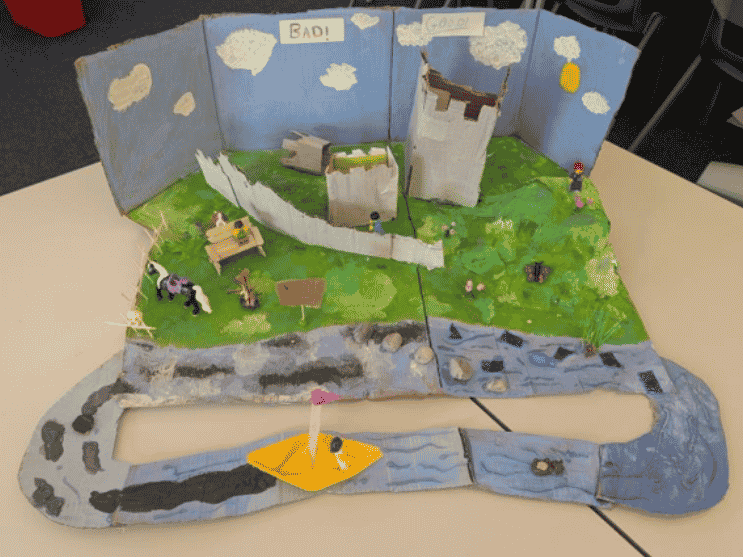
Our model shows Ogmore castle and the stepping stones, we made this structure out of cardboard, paint, scrap paper, pebbles, Christmas confetti scraps, newspaper, glue, wood, recycled plastic pots.
We did the Ogmore castle and stepping stones because it is in our local area and we have seen how fragile it is. It is fragile because people climb all over the castle and damage it and rocks from the castle will fall on people or animals. People may walk on rare bugs and leave litter and smashed glass on the floor that little kids and could cut themself on.
People also leave litter around and it goes into the river meaning it is polluting the river and the ecosystem.
Also, there are rare animals found here, and tourists are destroying their homes and habitats, the animals found her are high brown fritillary butterfly, yellow hammers, hazel dormice, and many more.
Our model shows a line through the middle splitting our project in half, we did this to show what the castle looks like now, with all the pollution, and people climbing over the castle meaning it has fallen down, and also, we did the vandalism on the stepping stones. We have done oil leaks coming off a boat.
Then on the other side we did what it should look like, with the blue, clean water and the endangered animals from our local area roaming freely, and their homes are not being destroyed. With the castle not broken because no one has climbed on it.
We did this to spread awareness about how we are destroying natural habitats and how we need to save them.
Judges comments:
‘This was an effective group model. The clear before-and-after presentation made the geographical idea easy to understand and gave the model a strong sense of purpose.’